- Date application duly made
- 18 September 1993
- Applicant name
- Wheldrake Parish Council
- Applicant address
-
2 Derwent Drive
Wheldrake
York - Relevant Definitive Map
- East Riding of Yorkshire
- Parish
- Wheldrake
- Nearby village and city
- Wheldrake, York
- Location details
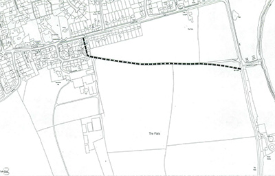
- Church Lane to Carr Lane
- Location map
-
- Post codes of properties affected by application
-
- YO19 6GA
- YO19 6GB
- YO19 6AR
- YO19 6AS
- YO19 6AX
- YO19 6FE
- YO19 6GG
- Intended effect
- Add footpath
- Grid reference start
- SE 6843 4500
- Grid reference end
- SE 6895 4490
- File status
- In progress
- Date determined by City of York Council
- 2 February 2010
- Determination
- Order made
- Additional notes
-
Objections received, to be sent to the Secretary of State for a final decision.
- Officer contact details
-
Rights of Way Officer
Email: rightsofway@york.gov.uk
Telephone: 01904 551550
Comment on this page