Proposed design
Since being awarded the funding, we have been working with engineers to design a scheme. This has included discussions with planning and also with the Environment Agency to identify ‘flood compensation’ areas.
Design ideas
Section A: from Kingsland Terrace to Cinder Mews

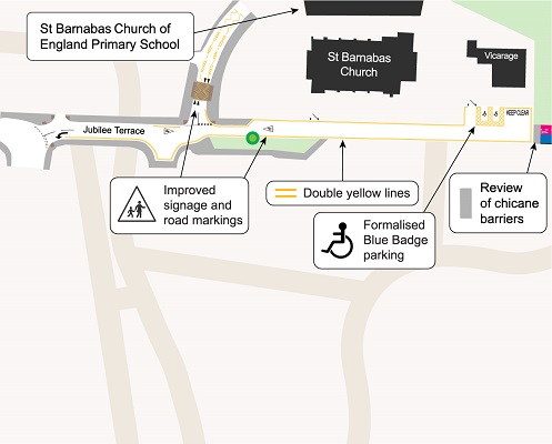
The proposed design for the Jubilee Terrace section
- formalises Blue Badge parking to design standards
- improves signage and road markings
- double yellow lines
- review of chicane barriers
- reduces conflict between parked vehicles and travelling public
- reduces traffic and traffic speed
Section B1

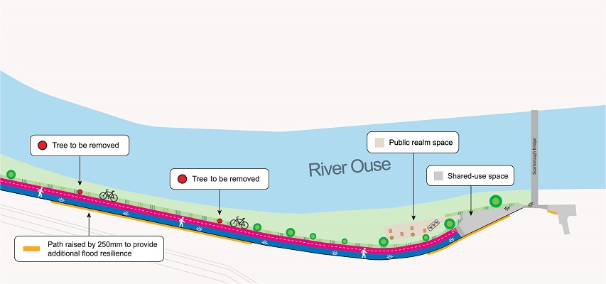
The proposed design for the middle section of the path (B1)
- introduces a separate cycle path which reduces conflict and increases capacity for different users
- partial footway resurfacing
- improves lighting, rest points and cycle parking
Section B2

The proposed design for the section of the path near Scarborough Bridge (B2)
- improves lighting and rest points along path
- raised path provides additional flood resilience. While raising the path level will not prevent flooding, it will reduce the number of days the path is closed.
- realigns the shared-use section of the path to allow for a better view of oncoming users
Key considerations
Separating Vs widening the route

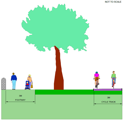
A cross-section diagram of the proposed separate cycle path
An important element of improving the path for users will be creating more space for pedestrians and cyclists. Numerous options were presented in the previous consultation. While strong support was shown for widening the path, all options were reviewed.
Our designers have suggested introducing a separate cycle path because:
- given the need to retain existing trees, widening the path would only increase the total width by 1-1.5m. The total width gained from a segregated path is approximately 2.5m meaning more space for people.
- cost analysis was undertaken and all options were similar within 11.3% difference.
- the future demand given the York Central stopping up order of Leeman Road was also taken into account. A separate path should also reduce the level of disruption caused during construction.
- it would increase capacity whilst reducing conflict between pedestrians and cyclists
Flood compensation storage area

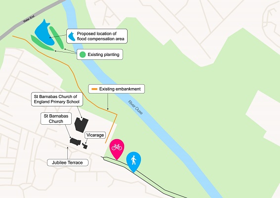
The proposed area for flood compensation
Given the proposals to raise the level of the path, the overall volume of land available to store flood water during a flood is reduced. To compensate for this, an area of land near Water End has been identified as an alternative location to provide this storage. The profile of the ground level will be lowered which will look like a dip in the field.
The design of the compensatory flood storage will be finalised at detailed design stage. A study will investigate the soil conditions, local geology and ecology to inform design of the compensatory flood storage, and the final design will require approval from the Environment Agency.
Impact on trees
We specifically recognise the importance of trees along the path, especially mature trees, and propose to retain them as far as possible within the design.
The design proposes that two ash trees are removed to provide the space required for the segregated cycle path, and to protect the path from potential root uplift. The third tree is a poorly formed collection of stems from ground level with limited future value.
Retaining as many trees as possible is a key priority for both the council and community, so these removals will be mitigated by the planting of five new trees in the area.


